Watershed Sciences
-
-
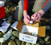
Stream Water Sampling Kit
WHONDRS Sampling Kits and Detailed Protocols Enable Coordination and Consistency in Sampling
Methodology. Shown is a stream water sampling kit that can be sent to anyone in the world interested in being involved with the project. The kit was designed to be simple and quick to use (sampling takes ~10 minutes), and it minimizes contamination by introducing the sample through a septum instead of opening the collection vials. These features make the kit amenable for use by both scientists and the public via citizen science efforts. -
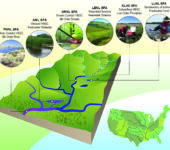
Subsurface Biogeochemical Research Test Beds
Subsurface Biogeochemical Research (SBR) test beds span the watershed continuum, from small headwater systems to a high-order main-stem river. Major field infrastructure in the test beds is complemented with fine-scale mechanistic efforts.
-
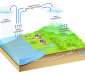
Watershed Landscape
Collaborating Across Environmental Science Domains. Terrestrial Ecology, Watershed Sciences, and Coastal Systems make up the three domains of the BER Environmental System Science program.
-
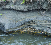
Bank of East River in Colorado
Section of river bank from the East River, near Crested Butte, Colorado.
-
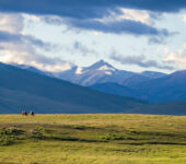
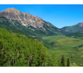
Mountain Hydroclimate Supports People and Animals
East River Watershed, Crested Butte, Colo.
-

River Corridor Watershed Researchers
Installation of an aquifer tube to monitor the hydrological exchange of river water and groundwater and associated biogeochemical processes in the Hanford Reach of the Columbia River. This work is supported by the Subsurface Biogeochemical Research activity.
-
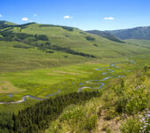
East River Catchment
Meandering stream in East River Catchment, Gunnison County, Colorado. One hypothesis is that hyporheic zone flow through organic carbon–rich sediments between meanders may have a large impact on integrated carbon cycling in the river basin. This occurrence suggests the need to capture hydrological and biogeochemical gradients at the fine scale (<1 m) and then upscale these gradients to the larger kilometer scale length of the river. Clearly a computational challenge, this process will require a new terrestrial modeling software framework.