Terrestrial Ecology
-
Vegetation Model
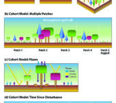
Vegetation Model that Tracks Cohorts on Patches Through Time and Calculates Ecosystem Fluxes and Vegetation Dyanmics. (a) Cohort-based models are an intermediate solution between unstructured, “big-leaf” models and stochastic individual-based models (IBMs). (b) Each land-atmospheric grid cell of a cohort model is divided into multiple patches with different forest stand structures. (c) Fluxes of water, energy, and carbon are calculated for each cohort and patch and aggregated to the grid cell. (d) Vegetation dynamics of recruitment, growth, and mortality transform individual patches through time, for example, regenerating a forest following disturbance by fire.
-
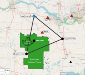
Location of the Third Atmospheric Radiation Measurement Mobile Facility (AMF3)
AMF3 is one of three ARM mobile monitoring facilities designed to collect atmospheric and climate data from undersampled and climatically impactful regions around the world. It will begin operations in northwestern Alabama’s Bankhead National Forest in fall 2024. The AMF3 5-year deployment, from 2024 to 2029, will monitor the effects of two-way feedbacks among aerosols, clouds, and precipitation on plant physiology and canopy-scale fluxes.
-

Atmosphere, Terrestrial, and Human Systems (ATH): Integrated Components of Mountainous Regions
Atmosphere, Terrestrial, and Human Systems (ATH): Integrated and Connected Components of
Mountainous Regions. Atmospheric conditions in mountain regions regulate water partitioning through the
terrestrial compartment (e.g., through infiltration and runoff partitioning to surface water and ground-water). Subsurface biogeochemical cycles from bedrock through vegetation regulate evapotranspiration fluxes back to the atmosphere; carbon dioxide fluxes from soils and streams; and watershed exports of carbon (C), nitrogen (N), and other elements. When water and elements reach downstream human systems, water regulation and decision-making become critical controls on water and elemental feedbacks to the atmosphere. -
-
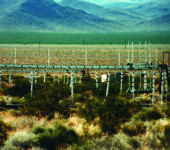
FACE Site in Nevada
The Nevada Desert FACE site was the only U.S. Department of Energy (DOE) FACE experiment that examined the impact of elevated atmospheric CO2 on arid ecosystems in an otherwise natural environment.
-
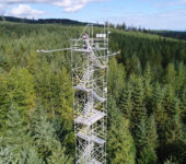
AmeriFlux Tower in British Columbia
Ca-Ca3 AmeriFlux Tower in British Columbia.
-
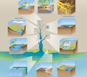
Terrestrial-Aquatic Interface Continuum
Terrestrial-Aquatic Interfaces (TAI) Continuum. This illustration shows the differences in spatial scale
of some of the commonly studied systems that TAI research seeks to integrate, namely interfaces associated
with headwater streams, rivers, wetlands and floodplains, estuaries, and coasts. These subsystems are connected to one another through hydrology, geomorphology, solute and particulate transport, and ecological
relationships, forming an integrated terrestrial-aquatic continuum from land to ocean. -
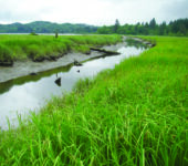
Freshwater Marsh in Washington
Tidal freshwater marsh near the mouth of the Columbia River in Washington.
-
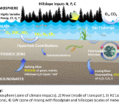
Hyporheic Zone Conceptual Model
Conceptual Model of the Compartments, Flows, Reactions, Feedbacks, and Pore-Scale Responses
to Large Temporal and Spatial Terrestrial Inputs Within a Hyporheic Zone. The combination of these processes leads to large-scale responses in discharge, gas, and concentration measurements used as calibration and validation data for Earth system models at various points within the numerical grid. Key: (1) Atmosphere (zone of climate impacts). (2) Stream (mode of transport). (3) Hyporheic zone (zone of reactions). (4) Groundwater (zone of mixing with floodplain and hillslope; scales of meters and hours). Abbreviations: C, carbon; CH4, methane; CO2 , carbon dioxide; DO, dissolved oxygen; DOC, dissolved organic carbon; ET, evapotranspiration; H2O, water; NO3, nitrate; N, nitrogen; O2, oxygen; P, phosphorus; precip, precipitation; Q, streamflow discharge; S, sulfur; T, temperature. -
Magnified Pine Root and Microbiome
Magnified view of a red pine (Pinus resinosa) root and associated microbiome.